
SatelliteMap
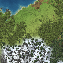
The map and the minimap show the world itself at any zoom instead of the game's map picture: real relief and shores, forest, player-made paths and fields, buildings, ruins and boss altars, drawn top-down from world data.Changelog
0.3.0
The whole map is drawn by the mod now: the game's own map picture is never shown.
- Zoomed out, the picture no longer fades into the game's map. Three more tile sizes (8, 16 and 32 m per pixel) cover every zoom, up to the whole world on one screen. That far out only relief, water and shores are drawn, straight from the world generator, without asking the server.
- Unexplored land is a clean sheet instead of the game's fog.
- While the detailed pieces wait for the server, a quickly drawn relief lies under them, so explored land never shows up empty. Zooming out, the next coarser picture is already there.
- The small corner map is drawn the same way.
DetailLevel = 0now means relief and water only, not the plain game map.- The
General / Enabledswitch is gone: there is no game map to switch back to.
0.2.0
Snapshots: a map can show the land as it was when it was charted, not as it is now. Nothing changes for the plain game map, it stays alive.
- Whoever runs the world (dedicated server, host, single player) remembers what a zone looked like when a player charted it and hands out a snapshot number. A new number appears only when the zone has changed since the last snapshot. Snapshots live in
<save folder>/satellitemap/<world>.<world id>.zones; back this file up together with the world. - New for other mods:
SatelliteMapApi.Survey(chart zones, get snapshot numbers) andSetZoneRevisionProvider(which snapshot to draw). ParchmentMap 0.3.0 uses them: changes show up on the parchment only after you walk there again and visit a cartography table. - Snapshots never change, so the client fetches each one once and never re-checks it.
- Works with older versions on the other side: an older server simply keeps sending the live world, an older client keeps getting it.
ServerSelfTestalso takes snapshots of the tested zones and asks them back by number.
0.1.6
For big, well-explored maps. Nothing changes in how the picture looks up close.
- Fixed: with the map zoomed far out over a fully explored area, one screen needs more zone descriptions than the memory limit of 0.1.5 allowed, so the client kept asking the server for the same zones over and over while the map was open. What the screen needs right now is never dropped any more.
- Zones arrive from the middle of the screen outwards, and zones of tiles that scrolled off the screen are no longer fetched.
- Re-checking zones costs almost nothing: the client sends fingerprints of what it already has and the server answers "unchanged" instead of sending the zone again (121 zones: 198 bytes instead of 113 KB). Works with an older server or client too, just without the saving.
- A fourth tile size, 4 m per pixel, for the far end of the zoom: a screen takes about thirty tiles instead of a hundred, and on wide monitors the picture reaches the corners.
- The server's 4 ms per frame is now shared by all players who opened the map at the same moment.
- If the server stopped answering (overloaded, or the mod was added later), the client asks again once a minute and buildings, paths and forest come back without re-entering the world.
0.1.5
- The server spreads a big map request over several frames (4 ms per frame), so describing a hundred zones with a large base in them does not make the game stutter for the players.
- A damaged packet from the network is rejected cleanly instead of failing half-way.
- The client keeps at most 6000 zone descriptions in memory; in a very long session with a big map the oldest ones are dropped.
0.1.4
- A building piece of another mod is now measured by the piece itself. Parts sitting far above it, like a placement ghost, no longer blow the box up to several metres.
0.1.3
- Fixed brown squares all over the meadows when PlantEverything is installed. That mod makes berry bushes, mushrooms, dandelions, stones and branches plantable by giving them a building-piece component, and SatelliteMap took every one of them for a building from another mod. Now only real building pieces of other mods are drawn as boxes.
- Berry bushes are drawn as bushes.
- The server sends about a quarter fewer objects in such worlds.
0.1.2
- Page fix: the pictures added in 0.1.1 pointed at a host most people cannot reach, so they are gone from the page.
0.1.1
- Pictures on the mod page: a base, the detail levels side by side, landmarks and the world. Nothing else changed.
0.1.0
- First release. Zoom in on the big map and the explored part shows the world itself: relief, water and shores computed by the game's own world generator, forest, rocks, player-made paths, fields and paved roads, buildings, ruins, dungeon entrances and boss altars.
- Three levels of detail (2 m, 1 m and half a metre per pixel), chosen by the zoom and limited by the
DetailLevelsetting. - Server part that describes the world to clients; without it only relief and water are drawn.
- A small interface for other mods to limit the level of detail and to report changes of the explored area.